RLDP Deposit 2018-2033
Appendices
Appendix 1: Housing trajectory
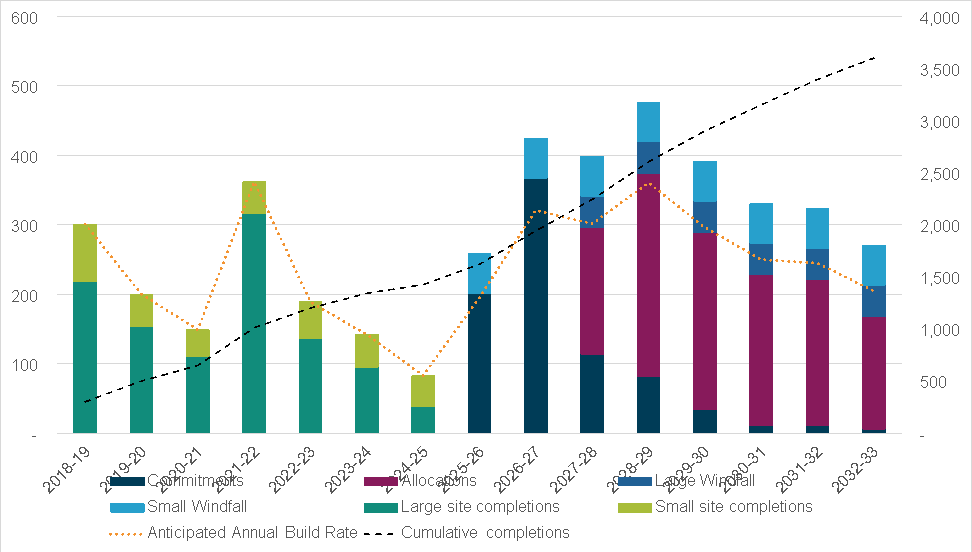
Table showing Conwy RLDP trajectory
Appendix 2: Conformity tables
Conformity of Conwy RLDP themes and policies with Planning Policy Wales:
|
National sustainable placemaking outcomes (PPW) |
Strategic and spatial choices in Conwy |
Healthy and social places in Conwy |
Prosperous places in Conwy |
Natural and cultural places in Conwy |
|
Maximising environmental protection and limiting environmental impact Has resilient biodiversity and ecosystems |
Yes |
Yes |
N/A |
Yes |
|
Has distinctive and special landscapes |
Yes |
N/A |
N/A |
Yes |
|
Has integrated green infrastructure |
Yes |
Yes |
Yes |
Yes |
|
Has appropriate soundscapes |
Yes |
N/A |
N/A |
Yes |
|
Reduces environmental risks |
Yes |
Yes |
N/A |
Yes |
|
Manages water resources naturally |
Yes |
Yes |
Yes |
Yes |
|
Has clean air |
Yes |
Yes |
Yes |
Yes |
|
Reduces overall pollution |
Yes |
Yes |
Yes |
Yes |
|
Is resilient to climate change |
Yes |
Yes |
Yes |
Yes |
|
Has distinctive and special historic environments |
Yes |
N/A |
N/A |
Yes |
|
Facilitating accessible and healthy environments: Has accessible and high quality green space |
Yes |
Yes |
N/A |
Yes |
|
Is accessible by means of active travel and public transport |
Yes |
Yes |
Yes |
Yes |
|
Is not car dependent |
Yes |
Yes |
Yes |
N/A |
|
Minimises the need to travel |
Yes |
Yes |
Yes |
N/A |
|
Provides equality of access |
Yes |
Yes |
N/A |
N/A |
|
Feels safe and inclusive |
Yes |
Yes |
Yes |
N/A |
|
Supports a diverse population |
Yes |
Yes |
Yes |
N/A |
|
Has good connections |
Yes |
Yes |
Yes |
N/A |
|
Has convenient access to goods and services |
Yes |
Yes |
Yes |
N/A |
|
Promotes physical and mental health and well-being |
Yes |
Yes |
Yes |
Yes |
|
Making the best use of resources Makes best use of natural resources |
Yes |
Yes |
Yes |
Yes |
|
Prevents waste |
Yes |
N/A |
Yes |
Yes |
|
Prioritises the use of previously developed land and existing buildings |
Yes |
Yes |
Yes |
N/A |
|
Unlocks potential and regenerates |
Yes |
Yes |
Yes |
Yes |
|
Is of high quality and built to last |
Yes |
Yes |
Yes |
Yes |
|
Growing our economy in a sustainable manner Fosters economic activity |
Yes |
Yes |
Yes |
N/A |
|
Enables easy communication |
Yes |
Yes |
Yes |
N/A |
|
Generates its own renewable energy |
Yes |
N/A |
Yes |
N/A |
|
Is vibrant and dynamic |
Yes |
Yes |
Yes |
Yes |
|
Is adaptive to change |
Yes |
N/A |
Yes |
N/A |
|
Embraces smart and innovative technology |
Yes |
Yes |
Yes |
N/A |
|
Creating and sustaining communities Enables the Welsh language to thrive |
Yes |
Yes |
N/A |
N/A |
|
Has appropriate development densities |
Yes |
Yes |
Yes |
Yes |
|
Has homes and jobs to meet society’s needs |
Yes |
Yes |
Yes |
N/A |
|
Has a mix of uses |
Yes |
Yes |
Yes |
N/A |
|
Offers cultural experiences |
Yes |
Yes |
Yes |
Yes |
|
Has community based facilities and services |
Yes |
Yes |
N/A |
N/A |
Conformity of Conwy RLDP themes and policies with Future Wales – the National Plan 2040:
|
Future Wales - the National Plan 2040 |
Strategic and spatial choices in Conwy |
Healthy and social places in Conwy |
Prosperous places in Conwy |
Natural and cultural places in Conwy |
|
Sustainable management of natural resources |
Yes |
Yes |
Yes |
Yes |
|
Biodiverse, resilient ecosystems |
Yes |
Yes |
Yes |
Yes |
|
Decarbonised and climate resilient |
Yes |
Yes |
Yes |
Yes |
|
Sustainable growth |
Yes |
Yes |
Yes |
N/A |
|
Sustainable travel |
Yes |
Yes |
Yes |
N/A |
|
Connected, inclusive and healthy places |
Yes |
Yes |
Yes |
Yes |
|
Health and socio-economic inequality |
Yes |
Yes |
Yes |
Yes |
|
Vibrant rural places |
Yes |
Yes |
Yes |
Yes |
|
Prosperity, innovation and culture |
Yes |
Yes |
Yes |
Yes |
|
World-class digital infrastructure |
Yes |
N/A |
Yes |
N/A |
|
Thriving Welsh language |
Yes |
Yes |
Yes |
Yes |
Conformity of Conwy RLDP themes and the national well-being goals:
|
National well-being goals |
Strategic and spatial choices in Conwy |
Healthy and social places in Conwy |
Prosperous places in Conwy |
Natural and cultural places in Conwy |
|
Globally responsible |
Yes |
Yes |
Yes |
Yes |
|
Prosperous |
Yes |
Yes |
Yes |
N/A |
|
Resilient |
Yes |
Yes |
Yes |
Yes |
|
Healthier |
Yes |
Yes |
Yes |
Yes |
|
More equal |
Yes |
Yes |
Yes |
Yes |
|
Cohesive communities |
Yes |
Yes |
Yes |
N/A |
|
Vibrant culture and thriving Welsh language |
Yes |
Yes |
N/A |
Yes |
Conformity of Conwy RLDP themes and the Conwy & Denbighshire Well-being Plan:
|
Conwy & Denbighshire Well-being Plan |
Strategic and spatial choices in Conwy |
Healthy and social places in Conwy |
Prosperous places in Conwy |
Natural and cultural places in Conwy |
|
Well being |
Yes |
Yes |
Yes |
Yes |
|
Economy |
Yes |
Yes |
Yes |
Yes |
|
Equality |
Yes |
Yes |
Yes |
Yes |
|
Housing |
Yes |
Yes |
N/A |
N/A |
Appendix 3: Supplementary Planning Guidance list
|
SPG title |
Policy section |
Relevant policy |
|
Sustainable placemaking and Design |
Placemaking |
PL/1 & PL/5 |
|
Promoting healthier places |
Placemaking |
PL/6 |
|
The Welsh Language |
Placemaking |
PL/7 |
|
Rural conversions |
Placemaking |
PL/10 |
|
Placemaking Plans and Place Plans Compliance Guidance |
Placemaking |
PL/11 |
|
New development, infrastructure and planning obligations |
Placemaking |
PL/12 |
|
New development and viability |
Placemaking |
PL/13 |
|
Householder Design Guide |
Placemaking |
PL/1 |
|
Placemaking Plans and Placemaking Compliance Assessments |
Placemaking |
PL/16 |
|
Affordable housing |
Housing and affordable housing framework |
HS/3, HS/4 & HS/5 |
|
Shared accommodation |
Housing and affordable housing framework |
HS/12 |
|
Parking Standards |
Sustainable transport and accessibility strategy |
STA/8 |
|
Shop front design and security |
Retail and town centre first strategy |
RTC/6 |
|
New Employment Sites in Urban and Rural areas |
Economic development strategy |
ED/3 |
|
Safeguarding B1, B2 and B8 Office and Industrial Sites |
Economic development strategy |
ED/4 |
|
Llandudno Holiday Accommodation |
Tourism strategy |
TO/3 |
|
Carbon Reduction in Planning |
Net-zero planning framework |
EN/1 |
|
On-Shore Wind Turbine Development |
Net zero planning framework |
EN/11 |
|
Renewable Energy |
Net zero planning framework |
EN/9 |
|
Landscape Sensitivity and Capacity Assessment for Onshore Wind Turbine Development |
Net zero planning framework |
EN/11 |
|
Green Infrastructure |
Natural Environment |
NE/7 |
|
Biodiversity in Planning |
Natural Environment |
NE/8 |
|
Landscape, Access, Design, Trees and Development |
Natural Environment |
NE/6 |
|
Coastal Flood Risk Protocol |
Environmental qualities |
EQ/5 |
|
The Castles and Town Walls of King Edward in Gwynedd World Heritage Site (WHS) Management and Action Plan |
Historic environment |
HE/2 |
|
Conservation Area Management Plans (various conservation areas) |
Historic environment |
HE/2 |
|
Conservation Areas (General) |
Historic environment |
HE/2 |
|
Historic Assets of Special Local Interest |
Historic environment |
HE/3 |
Appendix 4:
Background paper list
BP/1 - Growth level options report (housing & employment)
BP/2 - Spatial distribution options report
BP/3 – Settlement strategy
BP/4 - Sustainability appraisal and strategic environmental assessment
BP/5 - The habitat regulations appraisal
BP/6 - Site deliverability assessment
BP/7 - Housing land supply
BP/8 – Dark skies planning guidance
BP/9 - Local Housing Market Assessment. (LHMA) 2022-37
BP/10 - Affordable housing viability study
BP/11 - Affordable housing for local community need
BP/12 - Houses in Multiple Occupation (HMOs)
BP/13 - Houses in Multiple Occupation briefing note
BP/14 - Gypsy and traveller site options feasibility study
BP/15 - Gypsy and Traveller Accommodation Assessment (GTAA)
BP/16 - Planning and the rural economy
BP/17 - Employment land supply
BP/18 - Employment land review
BP/19 - Commercial market analysis
BP/20 - Skills needs assessment
BP/21 – Llandudno Holiday Accommodation Zone
BP/22 - Conwy County tourism assessment
BP/23 - Llandudno tourism study
BP/24 – Delivering public health and well-being priorities through LDPs in Wales
BP/26 - Retail hierarchy
BP/27 - Primary & secondary retail areas
BP/28 - Recreational space assessment
BP/29 - Green wedge assessment
BP/30 - Allotment site demand and supply report
BP/31 - Green Wedge update
BP/32 - Special landscape areas
BP/33 – Stage 1 Conwy Strategic Flood Consequences Assessment (SFCA)
BP/34 – Stage 2 Conwy Strategic Flood Consequences Assessment (SFCA)
BP/36 - Waste management
BP/37 - Minerals
BP/38 - Heritage designations
BP/39 - Historic Assets of Special Local Interest (HASLI)
BP/40 - Planning for active and sustainable travel
BP/42 - Welsh language impact assessment
BP/43 - Collaborative working with neighbouring authorities
BP/44 - Population change, housing & health/primary care impact
BP/45 - Population change, housing & education Impact
BP/46 - Place Plans
BP/47 - Green Infrastructure Assessment (GIA)
BP/48 - New housing occupancy study
BP/49 – Net-zero planning framework
BP/52 - Second homes & short term holiday lets
BP/54 - Tree cover in Conwy
BP/55 - Local Area Energy Plan (LAEP)
BP/56 - Employment land investment hierarchy update
BP/58 - Green infrastructure transforming towns
BP/60 - Renewable Energy Site Study
BP/61 - Town centres first study
BP/62 - Carbon sequestration and offsetting technical note
BP/64 - Transport and energy technical note
BP/65 - Achieving net zero in buildings
BP/66 - RLDP and social care
BP/67- Conwy RLDP safeguarded employment sites
BP/68 - Affordable housing led sites
BP/69 - Rural housing
BP/70 - Best and Most versatile (BMV) land justification paper
BP/71 - Health impact assessment
BP/72 - Equalities impact assessment
BP/73 - Placemaking Plans and Place Plans compliance guidance
BP/74 - Initial consultation report
BP/75 – Test of soundness report
Appendix 5: Implementation and delivery plan
The purpose of the implementation and delivery plan is to summarise the key issues, constraints, phasing and mitigation measures which are required to deliver proposals in the RLDP, from which monitoring indicators and triggers have been derived. It comprises a brief description of the key sites, together with an overview of site specific delivery and implementation issues, including site constraints, necessary mitigation / compensation measures and policy / S106 obligations / infrastructure requirements. This information will clarify the infrastructure requirements of key sites and alert potential developers in respect of expectations when bringing forward sites at the planning application stage with all relevant information known. All parties will know, in advance, what will be expected and consequently should be factored into the costs of bringing sites forward from the outset. This plan should be read alongside the site specific placemaking site policies in the Strategic and Spatial Choices Section and BP6: Site Delivery Assessment.
|
Site name and reference |
Site size |
Proposed use |
Phasing tranche |
Infrastructure and policy requirements |
|
Site 157 Caeffynnon, Llanfairfechan (West sub area) |
10.4 hectares |
Mixed-use for residential (145 homes), a new primary school, and recreational spaces and active travel routes. Starting point of 50% (73) affordable homes. |
2028-33 |
See policy PL/17 |
|
Site 91 Pentywyn Road, Deganwy / Llanrhos (Creuddyn sub-area) |
6 hectares |
Residential (140 homes), recreational spaces and active travel routes. Starting point of 50% (70) affordable homes. |
2028-33 |
See policy PL/18 |
|
Site 68 Peulwys Farm, Old Colwyn (Central sub-area) |
15.2 hectares |
Residential (300 homes), recreational spaces and active travel routes. Starting point of 50% (150) affordable homes. |
2028-33 Beyond 2033 |
See policy PL/19 |
|
Site 56 Penloyn, Llanrwst (Key Service Centre) |
5.5 hectares |
Residential (100 homes), recreational spaces and active travel routes. Starting point of 50% (50) affordable homes. |
2028-33 |
See policy PL/20 |
|
Site 203 Queen’s Road, Llandudno (Creuddyn sub-area) |
2.6 hectares |
Residential (70 homes), recreational spaces and active travel routes. Starting point of 50% (35) affordable homes. |
2028-33 |
See policy PL/21 |
|
Site 115 Llanddulas Quarry (East sub-area) |
26.8 hectares |
Employment use and associated renewable (solar) energy generation. Area 1: 0.8ha B1, B2, B8 Area 2: 4ha B1, B2, B8 Area 3: 4ha B1, B2, B8 Area 4: 18 ha for renewable energy (solar) |
Area 1: 2027-2029 Area 2: 2028-2032 Area 3: 2032 onwards Area 4: 2028-2033 onwards |
See policy PL/22 |
|
Site 103 Bryniau, Llandudno (Creuddyn sub-area) |
3.85 hectares |
B1 (business) employment. |
2028-2033 onwards |
See policy PL/23 |
|
Site 206 Nant y Coed, Llandudno Junction (Creuddyn sub-area) |
1.6 hectares |
100% affordable housing (50 homes) and associated works |
2023-28 |
See policy PL/24 |
|
Site 132 Dinerth Road, Rhos on Sea (Central sub-area) |
1.8 hectares |
100% affordable housing (50 dwellings) and associated work. |
2023-28 |
See policy PL/25 |
Appendix 6:
Glossary of terms
Adoption – the final stage in the process of producing a development plan, when it becomes the planning authority’s statutory development plan for the purposes of the Planning and Compulsory Purchase Act 2004
Adopted development plan – The development plan which has been adopted and is in use for development management purposes.
Affordable Housing – for the purposes of the land-use planning system it is housing where there are secure mechanisms in place to ensure that it is accessible to those who cannot afford market housing, both on first occupation and for subsequent occupiers. Affordable housing includes social rented housing owned by local authorities and RSLs and intermediate housing where prices or rents are above those of social rent but below market housing prices or rents. Affordable housing may also include that owned by community‑led housing organisations where this meets the Welsh Government’s definition.
ALAN - Artificial light at night. This is the cause of light pollution, nuisance and sky glow.
Allocated/Allocation – Land which is identified for a certain use (housing, retail, open space, etc), usually in a local development plan to support, in principle, that use within the timeframe of the plan.
AMR/Annual Monitoring Report – A report each year to the WG setting out progress against targets for preparing and revising development plans.
Article 4 Direction – some types of development do not require planning permission as they are ‘permitted development rights’. A local planning authority can introduce an Article 4 Direction for all or a specific area, which removes specific permitted development rights. Planning permission is then required for these works.
Cadw – the public organisation with responsibility for overseeing preservation of the historic environment in Wales.
CDSA – Coastal Development Strategy Area (as shown on the proposals map).
Commitments - undeveloped land with current planning permission or land which is currently being developed.
Community / communities – A general term used to describe the people who live together in a neighbourhood, village, commune, hamlet or centre of population. Communities can also be based around a religion, a set of interests, a profession, etc
CIL charging schedule – a development charge which LPAs may introduce which requires payment based on a per-square metre tariff, instead of seeking financial contributions via Section 106 agreement.
CIL Regulations – regulations setting out the process to enable LPAs to adopt a CIL charging schedule. CIL regulations 122 and 123 also set out tests
CIS / Community Involvement Scheme - Sets out the local planning authority’s approach and a timetable for involving local communities in preparing Local Development Plans. It is part of the Delivery Agreement which is submitted to the Assembly Government at the beginning of plan preparation. Certain bodies and groups must be given a chance to comment on a draft Community Involvement Scheme.
Completions – houses that have been built since the start of the Plan Period which contribute to the housing provision for the development plan.
Dark Sky -More than two-thirds of Wales has a dark sky, parts are internationally recognised as Dark Sky Reserves, Dark Sky Park, Dark Sky Sanctuary and as a Dark Sky Community. Lighting will be expected to be Dark Sky friendly.
DA / Delivery Agreement - A document which sets out the local planning authority’s timetable for preparing its Local Development Plan in accordance with the LDP Regulations. It also contains a Community Involvement Scheme, setting out how the authority will involve people, groups and organisations at different stage of plan-making. The Delivery Agreement needs to be agreed with WG.
DECCA Framework - the stepwise approach to biodiversity enhancement in Planning Policy Wales covering and Diversity, Extent, Condition, Connectivity and Aspects of ecosystem resilience.
Density – in terms of residential development, the number of dwellings per hectare of developable land.
Deposit – The period of public consultation once a local planning authority has prepared its intended final draft development plan. The Deposit Plan is the document, which is looked at by the Inspector at Examination, as well as comments on the plan from other people, groups and organisations.
Development - defined in Section 55 of the 1990 Town and Country Planning Act as "the carrying out of building, engineering, mining or other operation in, on, over or under land, or the making of any material change in the use of any building or other land." Certain activities may be of such a limited significance that the relevant local planning authority determines that they don't constitute development (i.e. are de minimis). Planning permission is normally required before development can take place, unless the proposal is permitted development.
Development management – the function of a LPA which deals with receiving, assessing and determining planning applications.
Development Plan – a document which sets out how land should be used and where development should take place over a given period of time. The development plan system in Wales is made up of three tiers, with plans prepared at national, regional and local levels.
Engage / Engagement – To take part in an active and involved way, usually in plan-making. Under the new planning system, local planning authorities should Engage with their Communities from an early stage of preparing Local Development Plans. Engagement means more than Consultation – it means people getting involved early in the plan-making process and not just commenting once a draft plan has been prepared.
Eryri National Park – previously known as Snowdonia, is protected for its landscape and culture. The Eryri National Park Authority is the LPA for the area within the national park.
Examination - a process by which the soundness of the LDP is tested in public and results in the Inspector(s) producing a report on the soundness of the LDP.
Future Wales – the National Plan 2040 is the Welsh Government’s national development framework, setting the direction for development in Wales to 2040. It is a development plan with a strategy for addressing key national priorities through the planning system, including sustaining and developing a vibrant economy, achieving decarbonisation and climate-resilience, developing strong ecosystems and improving the health and well-being of our communities.
Greenfield Land or Site - land (or a defined site) that has not previously been developed. This is land which does not fall under the definition of Previously Developed Land as set out in PPW.
Green Infrastructure - a network of multi-functional green space, urban and rural, which is capable of delivering a wide range of environmental and quality of life benefits for local communities.
Heneb - the trust for Welsh Archaeology
Infrastructure - basic facilities and services necessary for development to take place, for example, roads, electricity, sewerage, water, recreational spaces, education and health facilities.
Inspector – An independent, experienced planner who works for the Planning and Environment Decisions Wales. Looks carefully at detailed planning issues which are debated during examination of a Development Plan, or at a public inquiry into a specific proposal. Inspectors also decide appeals.
Key Service Centre – Relates to Llanrwst in the Rural Development Strategy Area.
LAEP / Local Area Energy Plan - sets out the carbon reduction and renewable energy interventions proposed in the county and covered in BP/55.
LDP / Local Development Plan - The required statutory development plan for each local planning authority area in Wales under Part 6 of the Planning and Compulsory Purchase Act 2004. A land use plan that is subject to independent examination, which will form the statutory development plan for a local authority area for the purposes of the Act. It should include a vision, strategy, area-wide policies for development types, land allocations, and where necessary policies and proposals for key areas of change and protection. Policies and allocations must be shown geographically on the Proposals Map forming part of the plan.
LDP Regulations – the process which must be followed by LPAs when producing a Local Development Plan.
LPA / Local Planning Authority - The local authority or council that is responsible for preparing plans and for making planning decisions. In Wales, there are twenty-five local planning authorities, including 22 unitary authorities and the three National Parks.
LSOA - lower super output areas are areas with low levels of economic activity and access to facilities and services, particularly for children, young people and elderly populations.
Material consideration - a relevant matter that should be taken into account in deciding a planning application. Whether or not something is material often depends on the individual case. Each case has to be considered on its own particular merit.
Mobile Action Zones (MAZ) are referred to in Future Wales – the National Plan 2040, however, the areas have yet to be designated spatially.
NRW / Natural Resources Wales – the public body with responsibility for managing public land and regulating environmental matters in Wales.
Open countryside – Any land area outside of the settlement boundaries.
PEDW Planning and Environment Decisions Wales.
Permitted Development – certain minor works that may be undertaken to properties without requiring planning permission, as set out in The Town and Country Planning (General Permitted Development) Order 1995 (as amended).
Placemaking – Placemaking is a people-centred approach to the planning, design and management of places and spaces. More information about Placemaking is available at the Design Commission for Wales website.
Placemaking Plan – a local level document normally initiated by local authority regeneration teams and are similar to Place Plans but can cover non-land use issues too.
Place Plan – a local level land use document prepared by town and community councils, or community groups where there is no local council. Can be adopted as supplementary planning guidance if in conformity with the Local Development Plan.
Plan Area – the part of Conwy County Borough (excluding Eryri National Park) which is covered by the Conwy LDP.
Planning and Compulsory Purchase Act 2004 - The primary legislation relating to development plans in Wales. The process for producing a Local development Plan is detailed in the LDP Regulations.
Planning application – the process and documents submitted by an applicant seeking planning permission for development. Documents required as part of a planning application submission include a planning application form, location plan, site layout and drawings to show elevations (external appearance of walls). A planning application is assessed against policies in the development plans and other material considerations. If the planning application is approved, the LPA will issue a certificate of planning permission.
Planning Obligation - a legal deed entered into under Section 106 of the Town and Country Planning Act 1990 to mitigate the impacts of a development proposal. They have to be necessary, directly related to the development and reasonable, and can take the form of financial contributions or require on-site provision of things like recreational space or affordable housing.
Planning Permission - formal approval given by a council, often granted with conditions, allowing a proposed development to proceed. Permission may be given in principle through outline planning applications, or be sought in detail through full planning applications.
PPW / Planning Policy Wales - Sets out the national policy framework for land use planning in Wales and includes many different areas of planning. Prepared by the Assembly Government to give local planning authorities and others a clear understanding of how national policy should be delivered at a local level.
Plan Period – the operational life span of a development plan. This is the time period over which development is planned, normally 15 years for a Local Development Plan.
Policy – the key sections of a development plan which set out development ambitions for the LPA, and criteria against which development proposals should be assessed. Further explanation about the policies are provided in supporting text.
Preferred strategy – A stage in the preparation of a Local Development Plan. The preferred strategy sets out in very general terms how an area will develop in the future. It gives the plan a central framework, which allows more detailed planning policies to be prepared for specific areas and topics.
PDL / Previously Developed Land - Previously developed land is that which is or was occupied by a permanent structure (excluding agricultural or forestry buildings) and associated fixed‐surface infrastructure. The definition as set out in PPW covers the curtilage of the development.
RLDP / Replacement Local Development Plan – the updated LDP as it is being prepared. Following Examination, if the RLDP is adopted it will replace the existing LDP.
Representation – Comments which are submitted to a Local Planning Authority. They can either be in support of something, or they can object to something. Representations are usually made in connection with a planning application, or a proposed policy in a Development Plan for the area.
RDSA – Rural Development Strategy Area is the part of the Plan Area outside the Coastal Development Strategy Area, as shown on the proposals map.
Rural – Although usually used in the context of the RDSA, when used singularly, the term ‘rural’ can relate to any area outside of the settlement boundary.
Section 106 Agreement - a type of Planning Obligation
Settlement boundary – line drawn around urban areas and other settlements and shown on the LDP Proposals Map, to separate settlements from the open countryside. Different policies will apply to a development proposal depending on whether a site is within or outside the settlement boundary.
Sound – Local Development Plans are tested by an Inspector at the Examination to see if they are Sound. The Inspector tests the plan using three ‘tests of Soundness’ which include 1. Does it fit? 2. Is it appropriate? and 3. Will it deliver?
SLA / Special Landscape Area – A local designation based on Landmap mapping to identify the most valued landscape areas which may not be protected or included in other designations.
Strategic Development Plan – A Strategic Development Plan (SDP) is a regional plan that focuses on planning issues that cross local authority boundaries. SDPs guide development and infrastructure provision over a broader geographical area than individual Local Development Plan. They will ensure that growth and change are managed in a coordinated way across the region. There will be four SDPs: South East Wales, South West Wales, Mid Wales and North Wales.
Supplementary planning guidance – Detailed guidance prepared by the local planning authority. Usually to do with a particular set of planning issues. It might cover a theme such as design and landscaping or be to do with a particular area. Often gives further detail of policies and proposals in a development plan. Does not need to be examined like a development plan but must be in line with development plan and national policies.
Sustainable Development – Looking after the world by using its resources in a sensible way. Or ‘Development that meets the needs of the present without compromising the ability of future generations to meet their own needs’. The planning system is important for Sustainable Development – it can bring about more sustainable ways of living and working. It can also encourage new types of Development which use less energy.
Transport Assessment – an assessment of highway capacity and safety to help inform the acceptability of a development.
Urban – Built-up or developed areas usually located within the Coastal Development Strategy Area (See CDSA) but can also relate to the Key Service Centre of Llanrwst which is located in the Rural Development Strategy Area.
WFG / Well-being of Future Generations Act – The WFG Act (Wales) 2015 is a key piece of legislation which aims to further improve the social, economic, environmental and cultural well-being of Wales now and in the longer term.
Welsh Government – the national government in Wales. It is responsible for the planning system in Wales and prepares national planning policy.
Windfall Sites - a site not specifically allocated for development which becomes available for development during the lifetime of a plan.
Appendix 7: Monitoring and review framework
All LDPs must include a monitoring framework. The indicators in the monitoring framework should be focussed on those key policies fundamental to delivering the plan. It should not be too onerous or too complex. All indicators should be specific, measurable and realistic. Not all policies/proposals in the development plan will require monitoring, only those key to delivering the plan strategy and objectives. Therefore, the monitoring framework below concentrates on national core indicators relevant to measuring the Conwy RLDP.
The monitoring framework sets out a number of indicators which form the basis for assessing the plan’s performance. These have been developed following the broad principles set out by Welsh Government and include a combination of mandatory, locally specific and contextual indicators. The framework focusses on key policies fundamental to delivering the plan, such as housing delivery, affordable housing provision, employment land take-up and Gypsy and Traveller provision. The monitoring framework clearly sets out which plan objectives, policies and proposals are relevant to each of the indicators. This will enable both the broad strategy of the Plan and its key policies, where necessary, to be monitored. Further information is provided in Section 6 of the RLDP.
The following indicators are required by LDP Regulation 37 and the Development Plans Manual:
- Contextual indicators
- National core indicators
- Local output indicators
- SEA/SA indicators
7.1 Contextual indicators
|
Indicator type |
Indicator |
Target |
Trigger point |
Source of information |
|
Local |
Population change |
No target |
No trigger point |
Population estimates, Office for National Statistics |
|
Local |
Household change |
No target |
No trigger point |
Household estimates, Welsh Government |
|
Local |
Number of Conwy County Borough residents out-commuting to work to locations outside of the County |
Overall reduction in out-commuting levels |
No decrease for 3 or more consecutive years |
Welsh Government Statistics and Research |
|
Core |
Financial viability factors: house prices and build costs |
No target |
No trigger point |
Land Registry, Build Cost Information Service |
|
Core |
The scale/type of highly vulnerable development permitted within zone 3 flood risk areas. |
No permissions granted against national policy |
1 application permitted in an AMR period |
Planning applications |
7.2 Strategic and spatial choices
|
Key policies |
Indicator type |
Indicator |
Target |
Trigger point |
Source of information |
|
PL/1, 5, 6 & PL/16-PL/25 |
Local |
Number of major planning applications which are accompanied by a ‘Placemaking Compliance Statement’ |
100% of all major planning applications are accompanied by a ‘Placemaking Compliance Statement |
1 or more major planning applications permitted without a ‘Placemaking Compliance Statement’ |
Planning applications |
|
PL/2 |
Core Reg 37 |
Number of net additional affordable and market dwellings built in the LPA area. |
Total annual build rate of 240 dwellings per annum, of which 98 are affordable |
Delivery is 10% below the build target for 3 consecutive years or 10% above the build target for 3 consecutive years |
SPPS surveys |
|
PL/2 |
Local |
Spatial distribution of housing development |
90% in the CDSA and 10% in the RDSA for plan period |
10% deviation in each strategic development area |
SPPS surveys |
|
PL/2 |
Core |
The annual level of housing completions monitored against the Anticipated Annual Build Rate (AABR) |
Annual housing completions delivered in accordance with the AABR and housing trajectory |
Annual delivery is 10% below the AABR for 3 consecutive years or 10% above the AABR for 3 consecutive years |
SPPS surveys |
|
PL/2 |
Core |
Total cumulative completions monitored against the anticipated cumulative completion rate (ACCR) |
Total housing completions delivered in accordance with the ACCR and housing trajectory |
Annual delivery is 10% below the ACCR for 3 consecutive years or 10% above the ACCR for 3 consecutive years |
SPPS surveys |
|
PL/7 |
Local |
Welsh language impact assessments completed |
100% in-line with policy requirements |
1 application not submitting a WLIA in the AMR period |
Planning applications |
|
PL/12 & 13 |
Local |
Infrastructure, planning obligations and viability |
100% of planning applications meeting PL/12 & 13 |
1 or more planning applications in a monitoring year |
Planning applications, viability assessments. |
7.3 Healthy and social places in Conwy
|
Key policies |
Indicator type |
Indicator |
Target |
Trigger point |
Source of information |
|
HS/7 |
Core |
The tenure of affordable housing completions |
Intermediate and social split in-line with the LHMA or other housing evidence |
3 applications not delivering housing mix in-line with policy requirements. |
CCBC Housing |
|
HS/3 & PL/13 |
Core |
Delivery of the affordable housing percentage targets for each sub-market area |
Delivery in-line with policy requirements |
1 application not meeting the affordable housing target |
Planning applications |
|
HS/2, PL/17 |
Core |
Rate of development at Llanfairfechan allocation |
Delivery in-line with the housing trajectory |
Annual completions falling below anticipated trajectory for three years School not delivered in accordance with Policy PL/17. |
Planning applications and SPPS surveys |
|
HS/2, PL/18 |
Core |
Rate of development at Deganwy / Llanrhos allocation |
Delivery in-line with the housing trajectory |
Annual completions falling below anticipated trajectory for three years. |
Planning applications and SPPS surveys |
|
HS/2, PL/19 |
Core |
Rate of development at Peulwys Farm, Old Colwyn allocation |
Delivery in-line with the housing trajectory |
Annual completions falling below anticipated trajectory for three years |
Planning applications and SPPS surveys |
|
HS/2, PL/20 |
Core |
Rate of development at Llanrwst allocation |
Delivery in-line with the housing trajectory |
Annual completions falling below anticipated trajectory for three years |
Planning applications and SPPS surveys |
|
HS/2, PL/21 |
Core |
Rate of development at Queen’s Road, Llandudno allocation |
Delivery in-line with the housing trajectory |
Annual completions falling below anticipated trajectory for three years. |
Planning applications and SPPS surveys |
|
HS/2, PL/24 |
Core |
Rate of development at Ysgol Nant y Coed, Llandudno Junction allocation |
Delivery in-line with the housing trajectory |
Annual completions falling below anticipated trajectory for three years |
Planning applications and SPPS surveys |
|
HS/2, PL/25 |
Core |
Rate of development at Dinerth Road, Rhos on Sea allocation |
Delivery in-line with the housing trajectory |
Annual completions falling below anticipated trajectory for three years |
Planning applications and SPPS surveys |
|
HS/10 |
Local |
Levels of second homes and short term holiday lets in communities |
Second homes and short-term holiday lets to make less then 15% of total housing stock |
15% in any community |
Council tax and non-domestic rates registers |
|
HS/12 |
Local |
Proportion of HMOs in cluster areas |
Number of HMOs does not exceed 10% of total dwellings within a 50m radius |
Concentration in cluster areas increases to 5% above base level |
Planning applications & CCBC Licensing |
|
HS/14 |
Core |
Provision of Gypsy, Romany and Traveller development generated from newly arising need outside of the GTAA |
Delivery in-line with the Policy HS/14 and newly arising need |
No planning permission on allocated sites where identified unmet need still exists |
Planning Applications. GTAA Reviews. |
|
HS/15 |
Core |
Completion of Gypsy and Traveller site allocation to meet identified need |
Identified need from the GTAA (2022) to be fully met by 2033. |
Provision not met in line with HS/15 and GTAA 2022 |
SPPS surveys, planning applications |
|
RTC/1 |
Local |
Annual vacancy rates of commercial properties within the Town Centres of the County Borough. |
Vacancy rates of commercial properties in the Sub-Regional Shopping Centre of Llandudno and Town Centres of Abergele, Colwyn Bay, Conwy, Llanrwst |
Vacancy rates of commercial properties in the sub-regional and town centres increase to more than 15% for 3 or more consecutive years. |
SPPS Town Centre Health Reports, surveys and planning applications |
|
RTC/3 |
Local |
The number of vacant and non-A1 units in the Llandudno Primary Shopping Area |
60% or more of units within the Llandudno Primary Shopping Area are in an A1 use. |
Less than 60% of units within the Llandudno Primary Shopping Area are in an A1 use. |
SPPS Town Centre Health Reports, surveys and planning applications, marketing approaches |
|
RTC/5 |
Local |
Safeguarding retail and leisure parks |
No loss where RTC/5 is not met. |
2 applications against RTC/5 with the monitoring year. |
SPPS Town Centre Health Reports, surveys and planning applications, |
|
RTC/7 |
Local |
New retail development |
Amount of major retail development (sqm) permitted outside of established sub-regional, town and local centre boundaries |
No major retail, development (sqm) permitted outside established sub-regional, town and local centre boundaries where contrary to RTC/7. |
SPPS Town Centre Health Reports, surveys and planning applications, |
|
CFS/2, 3, 4 & 5 |
Local |
New and existing social and community infrastructure |
No permission granted for development contrary to Policies CFS 2, 3, 4 & 5 |
1 or more planning permissions granted out of accordance with Policies CFS 2, 3, 4 & 5 |
SPPS Surveys, planning applications |
|
RS/2,3,4 |
Local |
New and existing recreational space |
No permission granted for development contrary to Policies RS 2, 3 & 4 |
1 or more planning permissions granted out of accordance with Policies RS 2, 3 & 4 |
SPPS surveys, planning applications |
|
STA/2 |
Local |
Provision of ultra-low and zero emission vehicles and infrastructure |
All major developments complying with STA/2 by assessing EV charging infrastructure via the submission of a compliant Energy Strategy. |
1 or more planning applications submitted without a supporting and compliant Energy Strategy. |
SPPS surveys and planning applications |
|
STA/3 |
Local |
Mitigating travel impact |
No permissions granted not in accordance with Policy STA/3: Mitigating travel impact |
1 application permitted contrary to STA/3 in any 1 year. |
Planning applications |
|
STA/4 |
Local |
Supporting transport routes and schemes |
No permissions granted not in accordance with Policy STA/4: transport routes and schemes |
1 application permitted contrary to STA/4 in any 1 year. |
Planning applications |
|
STA/5 |
Local |
Safeguarding rail freight and waste consolidation hubs/sites |
No loss of safeguarded rail freight hubs/sites as designated on the proposal map |
Loss of a safeguarded rail freight hub/site as designated on the proposals map |
Planning applications |
|
STA/6 |
Local |
New active travel and green infrastructure |
No permissions granted not in accordance with Policy STA/6: New active travel and green infrastructure |
1 application permitted contrary to STA/6: New active travel and green infrastructure in any 1 year |
Planning applications |
|
STA/7 |
Local |
improvements to public transport interchanges and facilities |
No permissions granted not in accordance with Policy STA/7: Improvements to public transport interchanges and facilities |
1 application permitted contrary to STA/7: Improvements to public transport interchanges and facilities in any 1 year |
Planning applications |
|
STA/8 |
Local |
Delivering parking standards |
No permissions granted not in accordance with Policy STA/8: Parking standards |
1 application permitted contrary to STA/8: parking standards in any 1 year |
Planning applications |
7.4 Prosperous places in Conwy
|
Key policies |
Indicator type |
Indicator |
Target |
Trigger point |
Source of information |
|
PL/3, ED/2 |
Core |
Employment land take-up against allocations |
Annual take-up of 0.5 hectares per annum |
Less than 0.25 hectares per annum for the first three consecutive years (average over the three years) then less than 0.5 hectare per annum (cumulative average) for the remaining plan period |
Planning applications /Employment Land Monitoring/Site visits |
|
PL/3, ED/2 |
Core |
Job growth (B class)- LPA wide |
80 jobs per annum |
Less than 50 jobs per annum for the first three consecutive years (average over the three years) then less than 70 jobs per annum for the remaining plan period |
Employment Land Monitoring /Floorspace to jobs ratios |
|
ED/2,3,4 |
Local |
Planning applications granted on allocated, safeguarded and employment improvement sites |
Land area equivalent to at least 1 hectare per annum |
Less than 0.5 hectare per annum for the first three consecutive years (average over the three years) then less than 1 hectare per annum for the remaining plan period. |
Employment Land Monitoring |
|
ED/3,6 |
Local |
Planning applications granted for employment floorspace in the rural area |
Land area equivalent to at least 0.1 hectare per annum |
Less than 500 sqm per annum for the first three consecutive years (average over the three years) |
Employment Land Monitoring /Planning applications |
|
ED/4 |
Local |
Amount of employment land on allocated, and safeguarded sites lost to: a) Non-B1, B2, B8 uses b) Non-operational employment generating uses |
No loss in accordance with ED/4 |
Further investigation of loss of employment land on allocated and safeguarded land |
Employment Land Monitoring |
|
TO/3 |
Local |
Level of Class C1 - Hotel uses within the Llandudno Holiday Accommodation Zone |
No loss in accordance with TO/3 |
1 |
SPPS surveys |
|
MW/2 |
Local |
Aggregate landbank of hard rock for Conwy County Borough Council in years. |
A minimum aggregate land bank of 10 years of hard rock to be maintained. |
Further investigation if 10 years land bank is not maintained |
Monitoring reports |
|
MW/2 |
Local |
Aggregate landbank of sand and gravel for Conwy County Borough Council in years. |
A minimum aggregate land bank of 7 years of sand and gravel to be maintained |
Further investigation if 7 years land bank is not maintained |
Monitoring reports |
|
MW/4 |
Local |
Sterilising developments permitted within buffer zones |
No sterilising developments permitted within buffer zones |
Further investigation and training if 3 or more sterilising developments are granted within buffer zones over two consecutive years. |
Planning applications |
|
MW/3 |
Local |
Sterilising developments permitted within mineral safeguarding areas |
No sterilising developments permitted within mineral safeguarding areas |
Further investigation and training if 3 or more sterilising developments are granted within buffer zones over two consecutive years. |
Planning applications |
|
MW/5,6 |
Local |
Planning permission for waste management facilities |
Maintain sufficient capacity to meet need and push waste higher up the waste hierarchy in accordance with the aspirations of national waste targets (70% of waste recycled by 2025 and zero waste / 100% recycling by 2050) |
Maintain sufficient capacity to meet need and push waste higher up the waste hierarchy in accordance with the aspirations of national waste targets (70% of waste recycled by 2025 and zero waste / 100% recycling by 2050) |
Planning applications |
7.5 Natural and cultural places in Conwy
|
Key policies |
Indicator type |
Indicator |
Target |
Trigger point |
Source of information |
|
EN/2- EN/7 & EN/10 |
Local |
Energy Strategy submitted in line with Polices EN/2-EN/7 & EN/10 |
All applications accompanied by an Energy Strategy in line with Policies EN/2 - EN/7 & EN/10 |
1 or more planning applications not accompanied by an Energy Strategy |
Planning applications |
|
EN/9 & 11 |
Local |
Number and capacity (MW) of renewable, low and zero energy carbon developments approved /implemented in line with Policies EN/9 & 11 |
No permissions granted or implemented against Policies EN/9 & EN/11 |
1 or more planning applications granted against Policies EN/9 & EN/11 |
Planning applications |
|
NE/2 & EQ/5 |
Core and Local |
Amount of development permitted within Zones 2, 3 and Defended Zones that do not meet all TAN 15 tests |
No applications approved within Zones 2, 3 and Defended Zones that do not meet all TAN 15 tests |
1 or more application permitted for development in any 1 year that does not meet all TAN 15 tests. |
Planning applications |
|
NE/3 & NE/4 |
Local |
Development approved against Policies NE/3 & NE/4 that adversely affects nationally or locally designated landscapes and Special Landscape Areas. |
No permission granted for development contrary to Policies NE/3 & NE/4 |
1 or more planning permissions granted out of accordance with Policies NE/3 & NE/4 |
Planning application |
|
NE/5 |
Local |
Development approved against Policy NE/5 which adversely affects a green wedge. |
No permission granted for development contrary to Policy NE/5 |
1 or more planning permissions granted out of accordance with Policy NE/5 |
Planning application |
|
NE/6 & NE/7 |
Local |
Number of Green Infrastructure Statements submitted in accordance with NE/6 & NE/7 |
All planning applications submitting a Green Infrastructure Statement in line with NE/6 & NE/7 |
1 or more planning applications not accompanied by a Green Infrastructure Statement as required by NE/6 & NE/7 |
Planning applications |
|
NE/8 |
Development approved against Policy NE/8 which adversely affects biodiversity, habitat or designated site. |
No adverse effects caused against Policy NE/8 |
1 or more planning applications |
Planning applications |
|
|
NE/9 |
Local |
Number of applications approved that would cause harm to the overall conservation value of Sites of Importance for Nature Conservation (SINCs), Regionally Important Geological Sites (RIGS) and Local Nature Reserves (LNRs) |
No permission granted for development contrary to Policy NE/9 |
1 or more planning permissions granted out of accordance with Policy NE/9 |
Planning application |
|
NE/10 & NE/11 |
Local |
Coastal Zone development |
No permission granted for development contrary to Policies NE/10 & NE/11 |
1 or more planning permissions granted out of accordance with Policies NE/10 & NE/11 |
Planning applications |
|
EQ/1-EQ/5 & EN/2 |
Local |
Environmental qualities - Development approved against Policies EQ/1 -EQ/5 which adversely impacts negatively on water conservation, air quality, soundscape and light, dark skies, sensitive lighting and flood risk. |
No permission granted for development contrary to Policies EQ/1-EQ/5 |
1 or more planning permissions granted out of accordance with Policies EQ/1-EQ/5 |
Planning applications |
|
HE/3 |
Local |
Number of applications granted contrary to policy HE/3 |
No departure from HE/3 |
1 or more departure applications permitted in relation to policy HE/3 per annum. (Commencing second AMR period) |
Planning applications |