Paper 2: Strategic Growth and Spatial Distribution Options
Option Assessment and Settlement Hierarchy
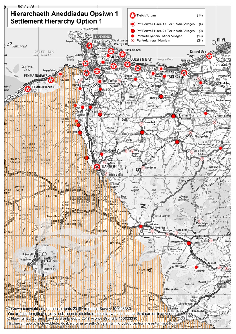
Adopted LDP (2007 - 2022) Settlement Hierarchy
The Conwy LDP (2007 - 2022) adopted a five tier settlement hierarchy (table below) based on a sustainability assessment of each settlement. The adopted LDP also identifies two strategic areas in which the settlements fall 'Urban Development Strategy Area' (UDSA) and the Rural Development Strategy Area (RDSA);
|
Option 1: Adopted LDP (2007 - 2022) Settlement Hierarchy |
|
Urban Development Strategy Area (UDSA) |
|
Urban Areas |
|
Abergele/Pensarn, Colwyn Bay (inclusive of Rhos-on-Sea and Old Colwyn), Conwy, Deganwy/Llanrhos, Llandudno, Llandudno Junction, Llanfairfechan, Llanrwst, Mochdre, Penmaenmawr, Penrhyn Bay/ Penrhynside and Towyn/Kinmel Bay. |
|
Rural Areas |
|
Main Villages (Tier 1) |
|
Llanddulas, Dwygyfylchi*, Llysfaen, Glan Conwy. |
|
Main Villages (Tier 2) |
|
Betws-yn-Rhos, Cerrigydrudion, Dolgarrog*, Eglwysbach, Llanfair Talhaiarn, Llangernyw, Llansannan, Tal-y-Bont*/Castell and Trefriw*. |
|
Minor Villages |
|
Bryn Pydew, Glanwydden, Groes, Henryd, Llanbedr-y-Cennin*, Llanddoged, Llanelian, Llangwm, Llannefydd, Pentrefelin, Pentrefoelas, Rhyd-y-Foel, Rowen*, St George, Tal-y-Cafn and Tyn-y-Groes. |
|
Hamlets |
|
Bodtegwel, Bryn-y-Maen, Brymbo, Bryn Rhyd-y-Arian, Bylchau, Capelulo*, Cefn Berain, Cefn Brith, Dinmael, Glan Rhyd, Glasfryn, Groesffordd, Gwytherin, Hendre, Llanfihangel GM, Maerdy, Melin y Coed, Nebo*, Pandy Tudur, Pentre-llyn-cymmer, Pentre Isa, Pentre Tafarn-y-Fedw, Rhydlydan, Tan-y-Fron. |
* Falls partly within the Snowdonia National Park
Option 1 Assessment Summary:
Option 1 continues with the settlement hierarchy introduced in the LDP and therefore lends itself to a logical option for continuity reasons alone. However the value and reasoning of the UDSA needs to be questioned. It also categorises some satellite settlements which are in close proximity to the main coastal settlements and therefore their synergy and growth rate is restricted. This approach also does not take account of the limitations on the coastal east settlements which are affected by flood risk.
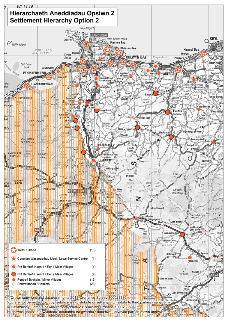
Option 2:
Same approach as Option 1 but amend the settlement hierarchy to move / reclassify selected settlements based on their sustainability. This option basically brings the adopted LDP up to date following a new appraisal of the settlements against certain sustainability criteria set out in BP03. For example, some settlements may have gained/lost essential community infrastructure which now impacts on the sustainability of the settlement and where it sits within the hierarchy.
|
Option 2: Same approach as option 1 but amend the settlement hierarchy to move / reclassify selected settlements based on an up-to-date sustainability assessment |
|
Urban |
|
Abergele/Pensarn, Colwyn Bay (inclusive of Rhos-on-Sea and Old Colwyn), Conwy, Deganwy/Llanrhos, Llandudno, Llandudno Junction, Llanfairfechan, Mochdre, Penmaenmawr and Penrhyn Bay/ Penrhynside and Towyn/Kinmel Bay. |
|
Rural |
|
Local Service Centre |
|
Llanrwst |
|
Main Villages (Tier 1) |
|
Llanddulas, Dwygyfylchi*, Llysfaen, Glan Conwy |
|
Main Villages (Tier 2) |
|
Betws-yn-Rhos, Cerrigydrudion, Dolgarrog*, Eglwysbach, Llanfair Talhaiarn, Llangernyw, Llansannan, Tal-y-Bont*/Castell and Trefriw* |
|
Minor Villages |
|
Bryn Pydew, Glanwydden, Groes, Henryd, Llanbedr-y-Cennin*, Llanddoged, Llanelian, Llangwm, Llannefydd, Pentrefelin, Pentrefoelas, Rhyd-y-Foel, Rowen*, St George, Tal-y-Cafn and Tyn-y-Groes. |
|
Hamlets |
|
Bodtegwel, Bryn-y-Maen, Brymbo, Bryn Rhyd-y-Arian, Bylchau, Capelulo*, Cefn Berain, Cefn Brith, Dinmael, Glasfryn, Groesffordd, Gwytherin, Hendre, Llanfihangel GM, Maerdy, Melin y Coed, Nebo*, Pandy Tudur, Pentre-llyn-cymmer, Pentre Isa, Pentre Tafarn-y-Fedw, Rhydlydan, Tan-y-Fron. |
* Falls partly within the Snowdonia National Park
Option 2 Assessment Summary:
This option brings forward the adopted LDP approach but provides the opportunity to appraise and update the settlement hierarchy. Llanrwst is defined on its own as it is considered unique within the county being a rural service centre serving several outlying villages, both within and outside of the plan area. The urban development strategy area is also removed but the settlements within the hierarchy remain the same.
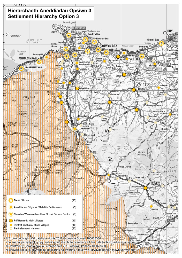
Option 3:
The same approach as in Option 2 above but with adjustments to the categorisation of certain settlements based on their close proximity and functional relationship to higher level urban settlements. For example, whilst some settlements have been classified as rural in the current LDP, some rural settlements fall within urban areas and meet good accessibility criteria to urban areas and as such could accommodate greater growth.
|
Option 3: The same approach as in Option 2 above but with adjustments to the categorisation of certain settlements based on their close proximity and functional relationship to higher level urban settlements. |
|
Urban |
|
Abergele/Pensarn, Colwyn Bay (inclusive of Rhos-on-Sea and Old Colwyn), Conwy, Deganwy/Llanrhos, Llandudno, Llandudno Junction, Llanfairfechan, Mochdre, Penmaenmawr, Penrhyn Bay/ Penrhynside and Towyn/Kinmel Bay. |
|
Satellite Settlements |
|
Llanddulas, Dwygyfylchi*, Glan Conwy |
|
Rural |
|
Local Service Centre |
|
Llanrwst |
|
Main Villages |
|
Betws-yn-Rhos, Cerrigydrudion, Dolgarrog*, Eglwysbach, Llanfair Talhaiarn, Llangernyw, Llansannan, Llysfaen, Tal-y-Bont*/Castell and Trefriw* |
|
Minor Villages |
|
Bryn Pydew, Glanwydden, Groes, Henryd, Llanbedr-y-Cennin*, Llanddoged, Llanelian, Llangwm, Llannefydd, Pentrefelin, Pentrefoelas, Rhyd-y-Foel, Rowen*, St George, Tal-y-Cafn and Tyn-y-Groes. |
|
Hamlets |
|
Bodtegwel, Bryn-y-Maen, Brymbo, Bryn Rhyd-y-Arian, Bylchau, Capelulo*, Cefn Berain, Cefn Brith, Dinmael, Glasfryn, Groesffordd, Gwytherin, Hendre, Llanfihangel GM, Maerdy, Melin y Coed, Nebo*, Pandy Tudur, Pentre-llyn-cymmer, Pentre Isa, Pentre Tafarn-y-Fedw, Rhydlydan, Tan-y-Fron. |
* Falls partly within the Snowdonia National Park
Option 3 Assessment Summary:
This option modifies the adopted LDP approach by re-classifying some of the Tier 1 Main Villages as Urban Satellite Settlements, due to their close geographical and functional links with urban settlements. This recognises their sustainable location in terms of proximity to transport connections, employment and amenities, whilst acknowledging that the settlements are smaller in scale than the urban areas, and proposed development should reflect this. As with Option 2, Llanrwst is classified as a rural Local Service Centre, rather than as an urban settlement. This is due to its unique position within the county as the main service settlement for a number of outlying villages, both within and outside of the plan area.
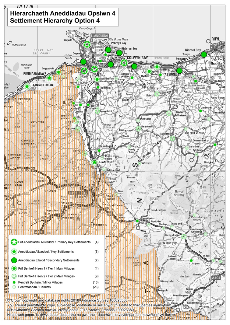
Option 4:
A new Settlement hierarchy which takes on board the Primary Key Settlements and Key Settlements identified in the Wales Spatial Plan (WSP). This option would see a further tier added to the urban areas to reflect the Primary Key Settlements and Key Settlements in the WSP.
|
Option 4: A new Settlement hierarchy which takes on board the Primary Key Settlements and Key Settlements identified in the Wales Spatial Plan (WSP). |
|
Urban |
|
Primary Key Settlements |
|
Llandudno, Llandudno Junction, Conwy, Colwyn Bay. |
|
Key Settlements |
|
Llanfairfechan, Llanrwst, Penmaenmawr, |
|
Secondary Settlements |
|
Abergele/Pensarn, Deganwy/Llanrhos, Mochdre, Old Colwyn, Penrhyn Bay/ Penrhynside, Rhos-on-Sea and Towyn/Kinmel Bay. |
|
Rural |
|
Tier 1 Main Villages |
|
Llanddulas, Dwygyfylchi*, Glan Conwy, Llysfaen. |
|
Tier 2 Main Villages |
|
Betws-yn-Rhos, Cerrigydrudion, Dolgarrog*, Eglwysbach, Llanfair Talhaiarn, Llangernyw, Llansannan, Tal-y-Bont*/Castell and Trefriw* |
|
Minor Villages |
|
Bryn Pydew, Glanwydden, Groes, Henryd, Llanbedr-y-Cennin*, Llanddoged, Llanelian, Llangwm, Llannefydd, Pentrefelin, Pentrefoelas, Rhyd-y-Foel, Rowen*, St George, Tal-y-Cafn and Tyn-y-Groes. |
|
Hamlets |
|
Bodtegwel, Bryn-y-Maen, Brymbo, Bryn Rhyd-y-Arian, Bylchau, Capelulo*, Cefn Berain, Cefn Brith, Dinmael, Glasfryn, Groesffordd, Gwytherin, Hendre, Llanfihangel GM, Maerdy, Melin y Coed, Nebo*, Pandy Tudur, Pentre-llyn-cymmer, Pentre Isa, Pentre Tafarn-y-Fedw, Rhydlydan, Tan-y-Fron |
* Falls partly within the Snowdonia National Park
Option 4 Assessment Summary:
This approach identifies the hub as shown by the Wales Spatial Plan and groups the Primary Key Settlements followed by those other Key Settlements in the coastal conurbation. The following categories remain the same. The majority of the LDP Area falls within the North East Wales Strategy Area of the Wales Spatial Plan. In addition, several settlements are either fully within the North West area, such as Llanfairfechan and Penmaenmawr, or fall in the area shared between both regions (Llandudno, Conwy, Llandudno Junction, Colwyn Bay and Llanrwst). This means that these cross-boundary settlements are strategically placed for connecting the two areas of Wales and beyond; via links to England and Ireland. Llanrwst has the added distinction of linking to a third Strategy Area: Central Wales. Llanrwst is considered unique within the county being a rural service centre which is a main town for several outlying villages, both within and outside of the plan area.
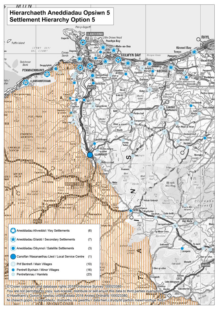
Option 5:
A hybrid which reflects Options 3 & 4 above. Under this option there would be an assessment of certain rural settlements based on their close proximity and functional relationship to higher level urban settlements and an additional tier included within the urban settlements to reflect WSP Primary Key Settlements and Key Settlements.
|
Option 5: A hybrid which reflects Option 3 & 4 above. |
|
Urban |
|
Key Settlements |
|
Llandudno, Llandudno Junction, Conwy, Colwyn Bay, Llanfairfechan, Penmaenmawr. |
|
Secondary Settlements |
|
Abergele/Pensarn, Deganwy/Llanrhos, Mochdre, Old Colwyn, Penrhyn Bay/ Penrhynside, Rhos-on-Sea and Towyn/Kinmel Bay |
|
Satellite Settlements |
|
Llanddulas, Dwygyfylchi*, Glan Conwy, |
|
Rural |
|
Local Service Centre |
|
Llanrwst |
|
Main Villages |
|
Betws-yn-Rhos, Cerrigydrudion, Dolgarrog*, Eglwysbach, Llanfair Talhaiarn, Llangernyw, Llansannan, Llysfaen, Tal-y-Bont*/Castell and Trefriw* |
|
Minor Villages |
|
Bryn Pydew, Glanwydden, Groes, Henryd, Llanbedr-y-Cennin*, Llanddoged, Llanelian, Llangwm, Llannefydd, Pentrefelin, Pentrefoelas, Rhyd-y-Foel, Rowen*, St George, Tal-y-Cafn and Tyn-y-Groes. |
|
Hamlets |
|
Bodtegwel, Bryn-y-Maen, Brymbo, Bryn Rhyd-y-Arian, Bylchau, Capelulo*, Cefn Berain, Cefn Brith, Dinmael, Glasfryn, Groesffordd, Gwytherin, Hendre, Llanfihangel GM, Maerdy, Melin y Coed, Nebo*, Pandy Tudur, Pentre-llyn-cymmer, Pentre Isa, Pentre Tafarn-y-Fedw, Rhydlydan, Tan-y-Fron |
* Falls partly within the Snowdonia National Park
Option 5 Assessment Summary:
This option takes brings forward the WSP approach along with accessibility and sustainability of current rural locations to urban areas, especially those in close proximity to the A55 corridor. These settlements may not have a full suite of facilities themselves however their close proximity to key and secondary settlements allows considerable interrelations for services. The approach reflects the constraints to the East of the County Borough and promotes a new Settlement Hierarchy that would potentially have the necessary capacity and available infrastructure to contribute to sustainable development. Llanrwst is considered unique within the county being a rural service centre which is a main town for several outlying villages, both within and outside of the plan area.
(3) Question 1: Which Settlement Hierarchy do you consider to be the best option? (Refer to Background Paper 3 'Hierarchy of Settlements' for greater assessment of the Options)
(3) Option 1
(1) Option 2
(4) Option 3
(4) Option 4
(5) Option 5
(4) Question 2: Are there any other settlement hierarchy options you would like to put forward?