Conwy Local Development Plan 2007 - 2022
4.6 THE NATURAL ENVIRONMENT
4.6.1 Spatial Objectives
SO11, SO12, SO14.
4.6.2 The Natural Environment Strategic Statement
4.6.2.1 The Plan Area benefits from attractive rural and coastal attributes which support a thriving tourism industry and provide a valuable leisure and recreation resource for residents. Policies in this section aim to protect and enhance the character of the countryside, landscape, built environment and the rich biodiversity and geological assets.
4.6.2.2 The countryside also supports a healthy agricultural economy and Government policy states that the location of the best and most versatile agricultural land should be taken into account alongside other sustainability considerations when determining planning applications.
4.6.2.3 As well as protecting the local environment, new development must also seek to limit the impact on the global environment by minimising resource use, increasing energy efficiency and reducing carbon emissions. The Spatial Strategy and sequential approach to its assessment directs development to be located in settlements that provide a range of services and facilities, reducing the need to travel (and therefore carbon emissions). Other policies in this section seek to increase the energy efficiency of buildings and increase production of renewable energy. There is also a need to ensure that development does not make wildlife and habitats more susceptible to loss through climate change and that they can adapt to future climate changes.
4.6.2.4 Much of the coastal area, particularly in the Urban Development Strategy Area, is at risk from flooding and there is a need to prevent inappropriate development in areas at risk. This risk is likely to increase in the future as a result of climate change and a rise in sea level. A restrictive approach is therefore applied to new development in areas at risk in line with Policy DP/6 – ‘National Planning Policy and Guidance’. Appropriate surface water drainage arrangements, such as Sustainable Drainage Systems, will be required to help control surface water flooding as set out in this section.
4.6.2.5 The open countryside consists of all areas outside defined settlement boundaries. National guidance seeks to conserve and, where possible, enhance the countryside for the sake of its ecological, geological, physiographic, historical, archaeological and agricultural value. The open coastline is important to amenity, wildlife and recreation. The Great Orme is designated as Heritage Coast because its limestone cliffs and grassland are recognised as being among the nation’s finest coastal scenery. The marine leisure industry and sea defence works both place pressure upon the coast. Such developments need to be sympathetic to the ecology and appearance of the coast. Likewise, some areas are likely to flood and development needs to be sited away from high risk areas.
STRATEGIC POLICY NTE/1 – THE NATURAL ENVIRONMENT
In seeking to support the wider economic and social needs of the Plan Area, the Council will seek to regulate development so as to conserve and, where possible, enhance the Plan Area’s natural environment, countryside and coastline. This will be achieved by:
- Safeguarding the Plan Area’s biodiversity, geology, habitats, history and landscapes through the protection and enhancement of sites of international, national, regional and local importance, in line with Policy DP/6 – National Planning Policy and Guidance’;
- Using Green Wedges and settlement boundaries to control the identity of individual settlements, to prevent coalescence and to protect the immediate landscape surrounding urban areas in line with Policy NTE/2 – ‘Green Wedges and Meeting the Development Needs of the Community’;
- Where appropriate and necessary, improving the quality of statutory and non-statutory landscapes and areas of biodiversity value affected by development, through management agreements, habitat connectivity, improved planting, landscape and maintenance specifications, in line with the Development Principle Policies and Policy NTE/3 – ‘Biodiversity’;
- Working with developers to safeguard protected species and enhance their habitats in line with Policies DP/6 and NTE/3;
- Seeking to minimise the loss of Grade 2 and 3a agricultural land to new development, in particular, in the east of the Urban Development Strategy Area, in line with Policy DP/6;
- Respecting, retaining or enhancing the local character and distinctiveness of the individual Special Landscape Areas in line with Policy NTE/4 – ‘The Landscape and Protecting Special Landscape Areas’ and as shown on the Proposals Map;
- Protecting the Coastal Zone in line with Policy NTE/5 – ‘The Coastal Zone’;
- Promoting energy efficiency and renewable technologies in development in line with Policy NTE/6 –‘Energy Efficiency and Renewable Technologies in New Development’;
- Preventing, reducing or remedying all forms of pollution including air, light, noise, soil and water, in line with Policy DP/6.
High Quality Agricultural Land
4.6.2.6 Paragraph 4.9.1 of Planning Policy Wales protects, where possible, the best quality agricultural land as this is a finite resource. There is no Grade 1 agricultural land within the Plan Area, although there are areas of Grade 2 and Grade 3a land in coastal areas. The Council will seek to minimise the loss of Grade 2 and Grade 3a land to new development although some may be necessary to ensure the housing targets are met. Planning applications affecting this issue will be subject to meeting the requirements of Policy DP/6.
Safeguarding Landscapes and Habitats
4.6.2.7 The quality and variety of the environment in the Plan Area is reflected in the number of sites of international and national importance. National policies seek to protect, and in some cases enhance designated areas of the countryside and coast, biodiversity rich areas, habitats of local importance, agricultural land and the urban environment. Planning applications that are likely to impact on these areas will be subjected to Policy DP/6.
4.6.2.8 The Plan Area contains diverse, high quality landscapes and areas of visual quality from the open moor land of Hiraethog to locally significant spaces around towns and villages. The western boundary of the Plan Area adjoins the Snowdonia National Park. Although the National Park Authority decides planning applications within its area, CCBC is the planning authority for adjoining areas which could affect the Park’s setting. In these areas, the Environment Act 1995 requires the Council to have regard to the purposes for which the National Park was designated.
4.6.2.9 Paragraph 5.2.8 of Planning Policy Wales promotes approaches to development which enhance biodiversity, prevent biodiversity losses, or compensating for unavoidable damage.
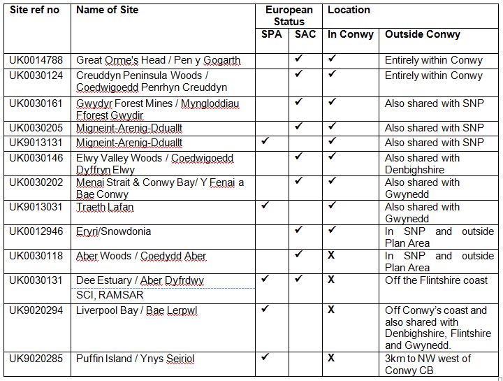
4.6.2.10 There are two Special Protection Areas (SPAs) and seven Special Areas of Conversation (SACs) which lie partly, or totally, within the Plan Area. SPAs and SACs are of international importance and consequently the European Directives and national policies afford them very high protection covered by DP/6. They are shown on the Key Diagram, assessed through the Habitats Regulations within BP/11 and listed in table 9 below:
Table 9: European sites within and adjacent to the Plan Area
4.6.2.11 Paragraphs 5.3.8 and 5.3.11 of Planning Policy Wales also protect biodiversity on sites of national importance (for example, Sites of Special Scientific Interest). Sites of local importance (such as Local Nature Reserves and Wildlife Sites) are not protected through national policies, but will be recognised in the LDP due to their local importance. Supplementary Planning Guidance (SPG) LDP5 – ‘Biodiversity in Planning’ provides further information on this topic.
4.6.2.12 Urban areas also contribute to biodiversity. The Plan Area has over 400 hectares of urban green spaces, such as parks, sports pitches and road verges. These sites provide habitats and can act as wildlife corridors to allow species to travel between sites. They are also important in terms of amenity, recreation and wellbeing.
4.6.2.13 The Local Planning Authority, Countryside Council for Wales and the North Wales Wildlife Trust have identified a network of sites of local importance for biodiversity which are considered as candidate ‘Wildlife Sites’. These sites, together with the nationally protected sites, form a habitat network which provides the foundation of the biodiversity resource in the Plan Area. Since a full evaluation of the entire candidate Wildlife Sites has not been carried out to date, their biodiversity value will be evaluated on a site by site basis when development proposals come forward in these locations.
4.6.2.14 Geodiversity relates to geological and geomorphological features. Such features include the Little Orme, which hosts a limestone pavement, and Llanddulas caves. Some sites have statutory protection such as Sites of Special Scientific Interest. In addition, Regionally Important Geological Sites are designated by regional groups on the basis of their scientific, educational, historic and aesthetic value. Planning applications that are likely to impact on these areas will be subjected to Policy DP/6.
4.6.2.15 Together these sites discussed above represent a strategic framework for the conservation of biodiversity and geodiversity. These sites include the statutorily protected international (Special Areas of Conservation and Special Protection Areas) and national (Sites of Special Scientific Interest) and locally protected Local Nature Reserves and County Wildlife Sites and RIG sites.
4.6.2.16 Trees and woodlands create and link habitats, contribute to landscape character and are increasingly managed as a renewable source of energy. The UK is one of the least wooded places in Europe. Only 12 per cent of the UK and 14 percent of Wales is woodland, compared to an average of 44 percent in other parts of Europe. Ancient and semi-natural woodlands, in particular, are protected through Planning Policy Wales as irreplaceable habitats. Retaining existing trees, and planting and maintaining new trees, within new developments contribute to visual amenity and biodiversity. SPG documents on both Biodiversity and Design provide information on biodiversity, integration, planting, maintenance, legislation, surveys and sustainable requirements of development. Planning applications that are likely to impact on trees or woodland will be subjected to Policy DP/6.
4.6.3 Green Wedges and Meeting the Development Needs of the Community
Policy NTE/2 – GREEN WEDGES AND MEETING THE DEVELOPMENT NEEDS OF THE COMMUNITY
To prevent coalescence of the settlements and retain the open character of the area, the following Green Wedges are designated as shown on the proposals map:
- Green Wedge 1 between Dwygyfylchi and Penmaenmawr
- Green Wedge 2 between Deganwy, Llandudno and Llanrhos
- Green Wedge 3 between Llandudno and Craigside
- Green Wedge 4 between Penrhyn Bay and Rhos on Sea
- Green Wedge 5 between Mochdre and Colwyn Bay
- Green Wedge 6 between Llandudno Junction and Mochdre
- Green Wedge 7 between Bryn y Maen and Colwyn Bay
- Green Wedge 8 between Llanelian and Colwyn Bay
- Green Wedge 9 between Coed Coch Road and Peulwys Lane
- Green Wedge 10 between Old Colwyn and Llysfaen
- Green Wedge 11 between Rhyd y Foel, Llanddulas and Abergele
- Green Wedge 12 between Towyn and Belgrano
4.6.3.1 Within the Plan Area, green wedges safeguard the undeveloped coast and countryside and prevent settlements from merging. A review of green wedge designations has taken place to inform this LDP as set out in BP/12 – ‘Green Wedge Assessment’. The designated green wedges are shown on the proposals map.
4.6.3.2 To meet the levels of development required to meet the needs of the community and tackle the key issues impacting on Conwy, the Council has to assess which areas of land are most suitable for development. As the amount of Conwy’s brown-field land is low, the Council will inevitably need to allocate new development on the periphery of settlements. The review of the Green Wedges has assessed which areas are the least damaging to the open countryside, existing settlement and landscape.
4.6.4 Biodiversity
Policy NTE/3 – BIODIVERSITY
- New development should aim to conserve and, where possible, enhance biodiversity through:
- Sensitive siting; avoiding European protected sites or those of national or local importance;
- Sensitive layout and design which avoids impacts or mitigates through an agreed programme for any identified adverse impact on biodiversity;
- Creating, enhancing and managing wildlife habitats and natural landscapes including connectivity;
- Integrating biodiversity measures into the built environment;
- Contributing to achieving targets in the Conwy Local Biodiversity Action Plan (LBAP);
- Providing for a management agreement with the Local Planning Authority to secure the retention and long term future of biodiversity interests where applicable.
- All proposals should include a Biodiversity Statement detailing the extent of impact on biodiversity.
- The Council will refuse proposals which would have a negative impact on a European Site, protected or priority species or habitat unless the impact is adequately mitigated and appropriate remediation and enhancement measures are proposed and secured by planning conditions or obligations.
4.6.4.1 The Council is committed to the protection and enhancement of biodiversity and will work with partners to ensure a proactive approach to the protection, enhancement and management of biodiversity in support of the Conwy Local Biodiversity Action Plan (LBAP). Whilst the need for development will be carefully considered against its impact on biodiversity, opportunities can arise through sensitively located and carefully designed developments. Change can bring about new opportunities where the use of conditions and Section 106 agreements can be used to create new habitats and manage existing ones.
4.6.4.2 Policy NTE/3 also applies to the potential impact of the development allocations made in this LDP and proposed development on Natura 2000 sites. BP/11 – ‘The Habitats Regulations Appraisal Screening Report’ sets out that all allocations within the plan are not likely to have a significant impact on Natura 2000 sites. Development will be permitted where it improves the appearance, biodiversity and landscaping of the site. Development proposals will only be allowed after it has been demonstrated that there will be no adverse impact on the integrity of the Natura 2000 Sites in accordance with Policy DP/6. The integration of biodiversity within new developments is an important part of sustainable development.
4.6.4.3 ‘Protected species’ are those species of plants and animals which are afforded legal protection, for example, under the European Union Birds Directive and Habitats Directive (these “European Protected Species” are the highest priority requiring protection), or under Schedules 1, 5 and 8 of the Wildlife & Countryside Act 1981 (as amended) and the Protection of Badgers Act 1992. Priority species or habitats are those defined in the UK Biodiversity Action Plan (BAP) or the Conwy LBAP.
4.6.4.4 Policy NTE/3 supports species protection legislation and Local Biodiversity Action Plan targets, and ensures that any harm to a species or habitat is weighed against the benefit of a development proposal. The judgement will be made on the basis of the expected effect on the species, the local, national or international significance of the population of the species, and its abundance, rate of decline or degree of threat.
4.6.4.5 As is detailed in the Development Principles section and, in particular, Policy DP/3 – ‘Promoting Design Quality and Reducing Crime’, when considering development proposals it is important to first afford priority to the maintenance and enhancement of existing habitats and species. The creation of compensatory habitat of species or habitats should only be considered as a measure of last resort. Where a species is affected mitigation and compensation measures should facilitate the survival of a species’ population, reduce disturbance to a minimum and provide adequate habitats to sustain at least the current level of a population.
4.6.4.6 Mitigation may include the provision of specific measures to reduce disturbance, harm or potential impacts, provision of adequate alternative habitats to sustain, and where possible enhance, the affected population, or facilitate the survival of individual members of the species. Such measures may be required through Section 106 agreements or planning conditions.
4.6.4.7 Policy NTE/3 also applies to the effects of development on people’s opportunity to enjoy and experience nature on a site. Development on or adjacent to an important site can have an adverse impact upon people’s enjoyment of the site’s biodiversity and landscape value, for example, through intrusive visual features, restrictions on access or a significant increase in noise levels.
4.6.4.8 Opportunities should be taken to achieve positive gain through the form and design of development. Where appropriate, measures may include creating, enhancing and managing wildlife habitats and natural landscape which could form the basis for a management agreement with the Council. Changes to the built environment should be viewed as an opportunity to fully integrate biodiversity within new development through innovation. Priority should be given to sites which offer habitat creation or linking which assists in achieving targets in the Conwy Local Biodiversity Action Plan (LBAP).
Biodiversity Duty
4.6.4.9 Section 40 of the Natural Environment and Rural Communities Act 2006 places a duty on all local authorities and other public authorities in England and Wales to have regard to the conservation of biodiversity in exercising their functions (biodiversity duty).
4.6.4.10 WG guidance on how LAs should comply with the biodiversity duty in the development control process states that key elements are screening development proposals for potential effects on biodiversity and seeking planning conditions and obligations to achieve biodiversity conservation. Further guidance is available in LDP5 – ‘Biodiversity in Planning’ SPG.
4.6.4.11 Paragraph 5.5.11 of Planning Policy Wales addresses the planning issues and in some cases, it may also be necessary for developers to obtain licences from the relevant authorities. The Council will work with developers to protect and enhance habitat for protected species and subject planning applications to Policy DP/6.
4.6.5 Special Landscape Areas
Policy NTE/4 – THE LANDSCAPE AND PROTECTING SPECIAL LANDSCAPE AREAS
- Special Landscape Areas are shown on the proposal map and designated in the following locations:
- Great Orme and Creuddyn Peninsula
- Conwy Valley
- Abergele hinterland
- Elwy and Aled Valleys
- Hiraethog
- Cerrigydrudion and the A5 corridor
- In order to conserve the attributes of the Special Landscape Areas development proposals will have to show particular regard to the character of each locality in order to minimise their impact. Development will only be permitted if it is shown to be capable of being satisfactorily integrated into the landscape. In appropriate cases planning applications should be accompanied by a Landscape and Visual Impact Assessment to assess the visual and landscape impacts of the development.
- All proposals, both within and outside SLAs, will be considered against the Development Principles and other policies in the Plan designed to protect the environment and landscape character.
4.6.5.1 The visual character of the landscapes, seascapes and townscapes in the Plan Area, and the separation of settlements, both within and outside of designated areas, is highly valued by residents and visitors. High priority is given to the protection, conservation and enhancement of this landscape character and new development should be well-designed and help sustain and/or create landscapes and townscapes with a strong sense of place and local identity.
4.6.5.2 The purpose of the designation is to ensure that the local character of these areas is not altered by inappropriate forms of development and that features which contribute to local distinctiveness are preserved. Poorly designed or sited development will be resisted. The design and materials used in the construction of that which is permitted should have regard to the local vernacular, and the siting and form of development should be such as to integrate with the landscape in a manner that is consistent with development which already exists. Guidance should be taken from LDP9 – ‘Design’ and LDP1 – ‘Householder Design Guide’ SPG.
4.6.5.3 LANDMAP, prepared by the Countryside Council for Wales, has been used to identify and describe distinctive Special Landscape Areas throughout the Plan Area. It incorporates details and values on habitat, historic, geological and cultural landscape qualitative. This information should be used, along with other studies that provide part of the evidence base about the landscape and the character of towns and villages in the Plan Area, to ensure that development proposals reflect the distinctiveness, qualities and sensitivities of the area.
4.6.5.4 Land falling outside of the SLAs is not instantly rendered suitable for development as there are other considerations and designations that could apply. LANDMAP may still also be relevant depending on layer coverage as most of the Plan Area is covered by at least one high value layer. A Landscape Character Statement will be required for all development outside of the settlement boundaries and outside of the SLAs, both defined on the proposals maps, and all development over 15 dwellings or 0.5 hectares inside the settlement boundaries.
4.6.5.5 A Landscape Character Statements can be incorporated in the Design and Access Statement where one is required or form a separate document. A Natural Environment SPG will be produced to provide further guidance on completion of a Landscape Character Statement.
4.6.5.6 The integration of development with the landscape should also have regard to landscape elements, such as walls, trees or hedgerows which are important to landscape character and should be retained. Development which is incapable of being sensitively and unobtrusively integrated into the landscape, and which would be detrimental to landscape character, will not be permitted. In certain cases, the proposed development may benefit from being landscaped, in a manner which is in keeping with the locality, to minimise its impact.
4.6.6 The Coastal Zone
Policy NTE/5 – THE COASTAL ZONE
A Coastal Zone is defined on the Proposals Map. Development in the Coastal Zone, outside settlement boundaries, will only be permitted where the development:
- Specifically requires a coastal location;
- Does not adversely affect the open character of the zone;
- Does not adversely affect the nature conservation value of the zone with any effects identified mitigated for;
- Does not detract from the tourism value or facilities;
- Does not interfere with natural coastal processes;
- Does not impede the function of any existing coastal defence structures;
- Accords with the Development Principles of the Plan.
4.6.6.1 The need to control development along coastlines is important for environmental and economic reasons. Coastlines warrant special protection as they are often sensitive to development due to their open character and they also provide habitats for certain species of plants, mammals and birds. In addition, development should not interfere with natural coastal processes such as erosion and deposition. TAN14 states that “it is for each LPA to consider and define the most appropriate coastal zone in its area”. From an economic point of view, the coast can be an important tourist and leisure attraction. Employment opportunities can be provided from other coast related activities such as fishing and marinas. Coastal areas may also be susceptible to flooding and, therefore, there may be a need to carry out defence works to protect areas from such risks.
4.6.6.2 A high proportion of Conwy’s coastline is protected from flood risk although breaching from the sea is a continual risk. Large areas of Conwy’s eastern coastline have previously been breached and the central Bay of Colwyn has suffered undermining to the seafront and storm damage, although further defence work began in 2011. To the west, Llanfairfechan seafront has also suffered from over-topping. TAN14 states that “Planning Authorities need to be aware of coastal issues on two scales; the site and its immediate environs and in terms of the wider setting”.
4.6.6.3 The undeveloped coast will be protected as it will rarely be the most appropriate location for new development. The developed coast, by contrast, may provide opportunities for restructuring and regenerating existing urban areas. Where new development requires a coastal location, the developed coast will normally provide the best option, provided that due regard is paid to the risks of erosion, flooding or land instability. The LDP will also offer opportunities for safeguarding land and routes for Emergency Planning scenarios.
4.6.6.4 Much of the coastal land resource in the Plan Area has already been developed, with the main centres of the population in the Plan Area located on the coast. The remaining undeveloped coast is considered to be one of Conwy’s major environmental assets.
4.6.6.5 The coastline of Conwy is a significant factor in attracting visitors to the area. Due to the role which tourism and recreation plays in the local economy it is important to maintain and enhance the attractiveness of the area through the development of improved facilities.
4.6.7 Renewable Energy and Sustainability in New Development
4.6.7.1 The Spatial Strategy, in the location of new development, is designed to minimise the need to travel, especially by car, thereby reducing carbon emissions. The design of new development is also important, as energy use in buildings accounted for nearly half of UK carbon dioxide emissions in 2004 and more than a quarter of these came from the energy used to heat, light, and power homes.
4.6.7.2 Climate change will have major implications on the UK’s environment and could result in more extreme weather events, including hotter and drier summers, flooding and rising sea levels leading to coastal realignment. This has severe consequences for the Plan Area, which is subject to large areas at risk of flooding.
4.6.7.3 The Council is seeking to ensure that all new development contributes towards sustainable principles and reduces or minimises carbon emissions, is resilient to future implications of climate change and protects residents from the effects of fuel poverty. New dwellings are likely to comprise the majority of new development in the Plan Area and the Code for Sustainable Homes is a national standard used to assess the sustainability of new dwellings. Particular Code for Sustainable Homes ratings should be met in order to ensure that the housing requirement is provided in a sustainable manner. The Code looks at dwellings in a holistic way and certain standards in terms of water consumption, environmental impact of materials used, provision of outside space, and protection of existing ecological features need to be met to reach a particular 'level'.
4.6.7.4 The policies in this section seek to achieve greater efficiency in the use of natural resources, minimise energy demand and increase the use of renewable resources. This should reduce the running costs of buildings and create attractive and healthy places for people to live and work by the use of natural light and ventilation. When looking at re-use of previously developed land, developers should seek to renovate existing buildings where appropriate rather than demolition and rebuilding. Recovered building materials should also be used where possible. This will reduce energy used in construction and will also contribute to protecting the built heritage.
Policy NTE/6 – ENERGY EFFICIENCY AND RENEWABLE TECHNOLOGIES IN NEW DEVELOPMENT
The efficient use and conservation of natural resources are essential to the overall quality of life within the Plan Area and to support wider social and economic sustainability objectives. The Council will:
- Promote high levels of energy efficiency through the application of sustainable design and construction techniques in all new residential developments (as set out in Strategic Policy HOU/1 – ‘Meeting the Housing Need’) and non-residential developments, in line with the Development Principles and other related policies within the Plan;
- Promote renewable energy sources within development proposals which support energy generation from biomass, marine, waste, solar and wind sources, including micro generation where this is acceptable, in terms of impact on quality of life, amenity, landscape, viability and biodiversity in line with Policies DP/6 and NTE/7 – ‘Onshore Wind Turbine Development’;
- Ensure that all new developments incorporate the principles of sustainable design such as: appropriate layout, massing, orientation, use of materials, rain water harvesting, energy efficiency, sustainable drainage, and waste recycling areas/storage in line with the Development Principle Policies and NTE/8 – ‘Sustainable Drainage Systems’, NTE/9 – ‘Foul Drainage’ and NTE/10 – Water Conservation’;
- Support proposals which minimise the use of new materials in construction, utilise recycled materials and maximise opportunities for the subsequent reuse of materials in line with the Development Principles and Strategic Policy MWS/1 – ‘Minerals and Waste’.
4.6.7.5 Sustainable Development is at the heart of the Conwy LDP and the Council is seeking to create communities that use natural resources sustainably. Efficient use of natural resources, particularly the burning of fossil fuels, is one of the main means of reducing greenhouse gas emissions and reducing the impact of climate change. The planning system affects the use of natural resources, including energy and minerals, and how we use and manage waste. By responsible and efficient use, we can minimise the impacts to the environment, whilst ensuring sustainable availability for future generations.
4.6.7.6 Planning Policy Wales seeks for Local Planning Authorities to integrate energy efficiency and conservation objectives into the planning and design of new development in their areas. There is an increasing need to reduce the amount of carbon released. Local materials with a low embodied energy will be favoured. Renewable energy schemes will be encouraged where appropriate but the best way of meeting these aspirational targets in this Borough is through encouraging the use of on-site renewable energy sources. Given the likely scale of new development in Conwy over the Plan period within the urban coastal belt areas, the potential contribution from this source is considerable. It could take various forms including localised wind generators, solar panels or photo-voltaic cells incorporated into buildings. Developments that are sustainably designed and constructed can provide local renewable energy sources, use less energy, minimise heat loss, use less water, optimise natural light, facilitate better recycling, provide sustainable urban drainage systems and use recycled construction materials.
The Planning and Energy Act 2008
4.6.7.7 The 2008 Act enables local planning authorities in England and Wales to set requirements for energy use and energy efficiency in their development plans. It gives local authorities the power to include in their development plan policies that impose reasonable requirements for:
- A proportion of energy used in development in their area to be energy from renewable sources in the locality of the development;
- A proportion of energy used in development in their area to be low carbon energy from sources in the locality of the development and;
- Development in their area to comply with energy efficiency standards that exceed the energy requirements of building regulations.
4.6.7.8 In July 2008 the Welsh Government issued a ‘Planning for Climate Change’ consultation paper seeking comments on possible changes to national planning policy including the following areas:
- The use of sustainable building standards to drive up the sustainability of buildings in Wales;
- A requirement that in future major development in Wales should incorporate on-site and/or near-site decentralised and renewable or low-carbon energy equipment contributing at least an additional 10% reduction in CO2 emissions, and;
- The ability for Local Planning Authorities to set higher standards in the above areas in their LDPs for strategic sites.
Code for Sustainable Homes and BREEAM
4.6.7.9 The Welsh Government has adopted the Code for Sustainable Homes to support its zero carbon aspirations. The code replaces the Ecohomes standard and applies to all new housing promoted or supported by the Welsh Government or Welsh Government Sponsored Bodies (WGSBs). Assessment of proposed developments will be expected to be submitted as part of planning application proposals.
4.6.7.10 The Code measures the sustainability of a new home against categories of sustainable design, rating the ‘whole home’ as a complete package. The Code uses a 1 to 6 star rating system to communicate the overall sustainability performance of a new home. The Code sets minimum standards for energy and water use at each level.
4.6.7.11 The Code also gives new homebuyers better information about the environmental impact of their new home and its potential running costs, and offers builders a tool with which to differentiate themselves in sustainability terms.
4.6.7.12 From 1 May 2008 a minimum of Code Level 3 will be required for all new housing promoted or supported by the Welsh Government whether:
- Directly procured;
- The subject of financial support;
- Joint ventures or;
- Projects on land sold, leased or disposed of in any other way for development.
4.6.7.13 It also applies to all new housing on land improved or reclaimed with the Welsh Government or WGSB funding that is still subject to financial clawback.
4.6.7.14 Registered social landlords are also being invited to identify schemes within their work programmes. This is part of a pilot that aims to develop projects to meet the requirements of higher Code Levels, namely Code Levels 4 and 5. Housing developments promoted or supported by the Welsh Government will follow this approach.
4.6.7.15 The Building Research Establishment Environmental Assessment Method (BREEAM) is still a requirement for non residential developments promoted or supported by the Welsh Government.
Renewable Energy Assessment
4.6.7.16 Planning Policy Wales requires local planning authorities to carry out local Renewable Energy Assessments (REA) to establish levels of energy use, explore options for renewable energy and identify strategic sites and their potential within the LDP Plan Area. Guidance documents were published by the Welsh Government as the Revised LDP was being finalised for consultation. However, the Council is committed to producing an REA and incorporating the results into the LDP during future review opportunities. The Council has also signed up to the European Covenant of Mayors and the Pathways to Zero Carbon project (PTOC). The collection of initial baseline information will inform both the PTOC project and the REA. The team producing the REA will work in collaboration with the team producing the PTOC, and the land use implications arising will be integrated into the LDP by means of early review.
4.6.7.17 The approach taken in Policy NTE/6 will be reviewed in light of new Government Guidance in line with Policy DP/6.
4.6.8 Onshore Wind Turbine Development
Policy NTE/7 – ONSHORE WIND TURBINE DEVELOPMENT
- The development of large or very large-scale (over 25MW) wind farms will be concentrated within the Clocaenog SSA in accordance with Policy DP/6 and be subject to a satisfactory Environmental Impact Assessment. Proposals will be expected to:
- Demonstrate measures for the safeguarding, remediation and enhancement of habitat and species and conform to the principles contained in the Clocaenog Statement of Environmental Master Planning Principles (SEMP);
- Ensure all details of associated ancillary development are submitted with the planning application as an integral part of the scheme;
- Ensure that the potential cumulative impacts on surrounding communities, landscape and environment are considered acceptable. Where the development of a wind farm is considered to have an unacceptable cumulative impact it will be refused;
- Demonstrate that the development will not lead to noise levels or shadow flicker that would be detrimental to the residential amenity of the surrounding area.
- Outside the Clocaenog SSA the development of medium-scale wind farms over 5MW and below 25MW will only be approved in exceptional circumstances in the context of the following:
- Acceptability in terms of other Local Development Plan policies;
- The potential cumulative impacts on surrounding communities, landscape and environment are considered acceptable. Where the development of a wind farm is considered to have an unacceptable cumulative impact it will be refused;
- The development will not generate noise levels or shadow flicker that would be unacceptably detrimental to the amenity enjoyed by nearby residents or by users of public rights of way or other recreational facilities or areas;
- A satisfactory Environmental Impact Assessment should propose measures for the safeguarding, remediation and enhancement of habitat and biodiversity;
- Where possible, turbines are located no less than 500 metres from an occupied dwelling or other noise-sensitive building;
- Within SLAs wind turbine schemes medium-scale or larger will be resisted;
- Exceptional circumstances are considered to be where there is an overriding need or capacity issue which cannot be met within the SSA.
- Micro and small scale wind turbine development (5MW and less) will only be supported where:
- It is of a proportionate scale in terms of predominant energy production to supply the building(s) which it directly serves;
- It does not compromise the ability of the SSA to achieve its anticipated target of energy production;
- Criteria 2 a) – f) above are met and where appropriate a satisfactory EIA has been submitted;
- Within SLAs wind turbines will not be permitted unless serving a dwelling or cluster of dwellings at micro scale.
Table 10 - NTE7.1: Wind turbine typologies:
| Category (Scale) | Output (broad output category*) | Supplementary criteria (to be read alongside Policy NTE/7) |
| Micro | Under 50kW |
|
| Small | Under 5MW |
|
| Medium | Over 5MW but below 25MW |
|
| Large | Over 25MW |
|
| Very Large | Over 25MW |
|
| Strategic | Over 50MW |
|
* These values are for guidance only. Efficiency and scale of units are continually subject to advances in technology and operational conditions, therefore these values are likely to increase and be amended and addressed through the LDP review process.
4.6.8.1 The Welsh Government is committed to delivering an energy programme to reduce carbon emissions. Its target of 1,120 MW of wind-generated electricity will mainly be generated from larger wind farms, located in seven Strategic Search Areas (SSAs). One of these, in Clocaenog Forest straddling the boundary of the Plan Area and the county of Denbighshire, could potentially generate around 280MW (per The WG Energy Policy Statement 2010). The precise boundary of the SSA will be shown on the Proposals Map. This line indicates the outer limit of the SSA boundary as shown on the TAN8 map. Supplementary Planning Guidance for onshore wind turbine development is being developed with Denbighshire County Council and should be given regard when considering all types of wind turbine development. An additional guidance document for developers has also been prepared and offers pre-application guidance and checklist.
4.6.8.2 National policies also encourage smaller, community-based wind farm schemes, typically of less than 5MW, as well as other forms of renewable energy, such as biomass, geothermal and CHP where their effects are considered acceptable. Stand alone renewable energy projects that are sympathetic to landscape character and local amenity will also be supported.
4.6.8.3 Policy NTE/7 is designed to promote wind turbine development in the right locations at the appropriate scales in the context of targets proposed by the Welsh Government for power generated by onshore wind. Larger developments should be concentrated in the Clocaenog SSA as identified in TAN8. The Council also wish to promote the use of the Clocaenog Statement of Environmental Master Planning Principles (SEMP), developed by the RSPB in conjunction with Denbighshire and Conwy local planning authorities, CCW and the North Wales Wildlife Trust. This establishes a cross-boundary approach to land management in order to maintain, improve or create habitats affected by large scale wind turbine development.
Cumulative Impacts
4.6.8.4 These are the combined impacts as a result of the development with other existing and planned development. In assessing cumulative landscape and visual impacts, the scale and pattern of the turbines including ancillary development will be relevant considerations. It will also be necessary to consider the significance of the landscape and the views, proximity and inter-visibility, and the sensitivity of visual receptors. There may also be cumulative environmental and/or social impacts.
Community Benefit
4.6.8.5 Community benefit is referred to in TAN8 and may go some way to ameliorate the community consequences of impacts in which the landscape and other depreciation of the quality of life may be compensated. It falls to be negotiated with developers but is not a mandatory requirement or a material consideration in the determination of planning merits and should not be viewed as a means to overcome fundamental planning objections to a particular development. There is no entitlement to site a wind farm development in a particular location or to gain from a developer doing so but community benefits may reasonably be regarded as:
- Promoting good neighbour relations;
- Offering compensation for community disbenefits;
- Sharing the rewards with local communities.
4.6.8.6 Community benefit may fall within a number of categories (e.g. social, economic, environmental, ecological or educational benefits) and contributions may take a number of forms such as:
- Community funds: regular or one-off sums to a community fund which is agreed at application stage or before;
- Benefits in kind: infrastructure, environment, education or facility improvements agreed with the LPA and Community at application stage or before;
- Local Ownership: shares in the project or operating company are offered to local residents either using their own investment, profit-sharing or part-ownership schemes designed to tie community benefits to wind farm performance;
- Local contracting and management: the use of local employment during construction and operation of the wind farm.
The LPA will seek to negotiate Community Benefits in respect of wind farm development as a means to off-set or compensate for community impacts.
4.6.8.7 The impacts of wind farms on local communities, including cumulative impacts, need to be considered when determining proposals including those within the SSA. The focus of Environmental Impact Assessment tends to be on environmental impacts particularly on landscape, habitats and species rather than impacts on human communities. In order to determine whether or not there is an unacceptable impact on people and communities (including aesthetic and other changes to the environment) developers should consider the impacts of proposals on local populations including the assessment of local economy, health and well being. This should include consultation with affected communities and identify measures to mitigate, remediate and/or compensate for negative impacts.
4.6.9 Sustainable Drainage Systems
Policy NTE/8 – SUSTAINABLE DRAINAGE SYSTEMS
- The use of Sustainable Drainage Systems will be required wherever reasonably practicable with preference for on site disposal and where satisfactory arrangements can be put in place for the long term maintenance of those systems. Where this is not proposed a developer will need to justify that discharge is necessary and is adequately controlled.
- Subsequent preference for surface water drainage will be for:
- Drainage to a surface water body (river, lake etc.) subject to appropriate treatment and attenuation;
- Drainage to surface water sewer;
- Drainage to combined sewer.
- The developer must demonstrate that higher preference drainage options are unfeasible before proposing less sustainable options.
4.6.9.1 The use of Sustainable Drainage Systems (SuDS) to manage water flows can be an important tool in minimising flood risk by increasing permeable surfaces in an area which allows water to seep into the ground rather than running off into the drainage system and reduces the impact of diffuse pollution from run-off and flooding. The effective use of permeable surfaces, soakaways and water storage areas should be incorporated in all new development where technically possible. Early consideration of SuDS is required in order that a range of techniques can be considered and developers are encouraged to enter into early discussions with the Council.
4.6.9.2 It is preferable to manage surface water runoff through the use of Sustainable Drainage Systems (SuDS) as they provide environmental, biodiversity and aesthetic benefits. SuDS may take the form of swales, lagoons, permeable paving, green roofs and sensitively re-engineered channels or reed beds, depending on the nature of the development and the area.
4.6.9.3 When the Sustainable Drainage section of the Flood and Water Management Act is commenced, developers will require permission from the SuDS Approval Board (SAB). This will usually be a joint application alongside the planning process. It will therefore be necessary for drainage schemes to be put in place from the start of the design process and detailed in the DAS. Drainage design will be approved by the SAB and details of the required maintenance will also be needed as the SAB will be responsible for adopting SuDS which are constructed in accordance with the approved design (except for SuDS serving a single property). The SAB is the responsibility of the Lead Local Flood Authority but it is possible that a number of authorities will combine (to produce a North Wales SAB for example). National guidance is currently being prepared and will be considered under DP/6. The Water Framework Directive should also be referred to for considering any development which may have an impact on a river, lake or estuary. This assessment should be included in the DAS or Biodiversity Statement.
4.6.10 Foul Drainage
Policy NTE/9 – FOUL DRAINAGE
- Foul drainage to an adopted sewer should be provided wherever possible, in compliance with Welsh Ministers Build Standards which are effective from 1 October 2012. The development of sites where drainage to a public sewer is not feasible will only be permitted if proposed alternative facilities are considered adequate and would not pose an unacceptable risk to the quality or quantity of ground or surface water or pollution of local watercourses or sites of biodiversity importance.
- Development proposals which include vehicle parking and other hard surface areas used by vehicles must include measures such as trapped gullies and petrol / oil interceptors or other suitable methods of pollution control to safeguard against pollution of the water environment.
4.6.10.1 Development in the countryside, normally being development for agricultural purposes, including slurry from large agricultural installations, may be unacceptable if untreated effluent could enter local watercourses and the wider water environment. It will, therefore, be essential for such developments to provide plant which will treat their effluent if connection to the public sewer is not feasible. The policy makes it clear that the Council will not give planning permission for any development where it may prejudice the quality of ground or surface water, watercourses or sites of biodiversity importance unless measures are undertaken to mitigate the harm.
4.6.10.2 Where petrol, chemical or oil tanks or other facilities form part of a proposed development, the Council will normally require them to be contained by bund walls of sufficient size to prevent spillage or seepage.
4.6.11 Water Conservation
Policy NTE/10 – WATER CONSERVATION
All development should incorporate water conservation measures where practicable and conform to BREEAM standards promoting water conservation, efficiency measures and utilize SUDS techniques. Development proposals greater than 1,000 m2 or 10 dwellings should be accompanied by a Water Conservation Strategy.
4.6.11.1 There are a number of ways water conservation can be achieved, such as water saving devices, rainwater harvesting and grey-water recycling, and the policy offers a degree of flexibility on the exact methods used. Large developments or the cumulative impact of smaller developments, incorporating such measures could, by reducing surface water run-off, have the potential to reduce levels of water courses and water tables, and thereby have an impact on biodiversity. A balance must be achieved between management of water recycling and ensuring no adverse impact on the water environment and biodiversity.